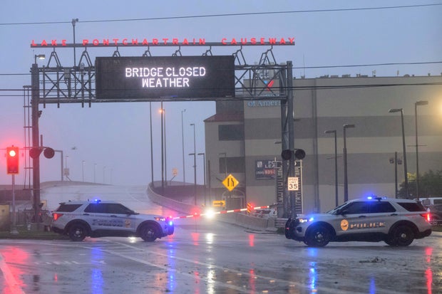
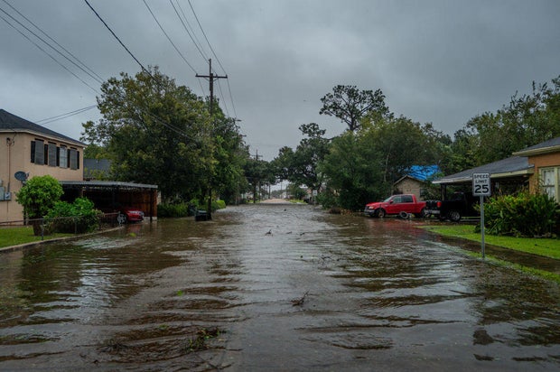
Hurricane Francine slammed into the Louisiana coast Wednesday evening as a dangerous Category 2 storm that knocked out electricity to tens of thousands of customers and threatened widespread flooding as it sent a potentially deadly storm surge rushing inland along the Gulf Coast.
Francine crashed ashore in Terrebonne Parish, about 30 miles southwest of Morgan City, the National Hurricane Center announced at 4 p.m. CDT. Packing maximum sustained winds near 100 mph, the hurricane then battered a fragile coastal region that hasn’t fully recovered from a series of devastating hurricanes in 2020 and 2021.
Morgan City Fire Chief Alvin Cockerham said the hurricane quickly flooded streets, snapped power lines and sent tree limbs crashing down.
Matthew Hinton / AP
“It’s a little bit worse than what I expected to be honest with you,” Cockerham said of the onslaught. “I pulled all my trucks back to the station; it’s too dangerous to be out there in this.”
More than 221,000 customers were without power across Louisiana Wednesday night, according to utility tracker PowerOutage.us.
TV news broadcasts from Louisiana’s coastal communities showed waves from nearby lakes, rivers and Gulf waters thrashing sea walls. Water poured into city streets and neighborhoods amid blinding downpours. Oak and cypress trees leaned in the high winds, and some utility poles swayed back and forth.
Hardest hit by the blackouts was Terrebonne Parish near where the storm’s center hit land, as well as neighboring St. Mary Parish that includes Morgan City.
Louisiana braces for the worst
Terrebonne Parish President Jason Bergeron told CBS News on Wednesday that the levies were holding, but the water is rising.
“The ground is saturated with water, and as the levy system is closed that water has a harder time getting out, except for some areas that have some pumps,” Bergeron said.
Sheltering at her mother’s home just outside Morgan City, Laura Leftwich said blasts of wind had swept away two large birdhouses outside. She had a generator powering an internet connection so she could video chat with friends, holding her computer to a window to show them water overflowing in the street.
If the storm had been any more intense, “I wouldn’t have the guts to look outside,” said Leftwich, 40. “It’s a little scary.”
The National Hurricane Center urged residents to stay sheltered overnight as the hurricane blows inland. The storm’s projected path included New Orleans, where forecasters said the storm’s eye could pass through.
Brandon Bell / Getty Images
“Conditions are going to go downhill really rapidly over the next couple of hours,” Jamie Rhome, the hurricane center’s deputy director, said in an online briefing prior to landfall. “It’s not going to be a good night to be driving on the roads, especially when the sun goes down.”
Bands of heavy rain began pelting New Orleans on Wednesday morning and were expected to intensify with the approach of Francine. New Orleans could see up to 10 inches of rain, putting the city’s water pump and drainage system to the test.
“Stay inside, hunker down,” New Orleans Mayor LaToya Cantrell said in a news briefing Wednesday. “Now is the time, between now as well as moving into midnight.”
A flash flood emergency was declared for New Orleans, Metairie and Kenner until 11:45 p.m. local time, the National Weather Service said.
Francine expected to weaken rapidly
Francine drew fuel from exceedingly warm Gulf of Mexico waters, strengthening to a Category 2 storm hours before landfall, the National Hurricane Center said. Category 2 hurricanes are classified as having winds of between 96 to 110 mph that are capable of extensive damage.
Still dangerous, the hurricane began weakening as it rushed inland, dropping in less than two hours back to a Category 1 storm with top winds of 85 mph. Francine continued moving northeast at a fast clip of 17 mph on a path toward New Orleans, about 55 miles away.
Brandon Bell / Getty Images
It was forecast to weaken further while pushing northward through Mississippi on Thursday, with widespread rains in the coming days bringing potential flash flooding to cities including Jackson, Mississippi; Birmingham, Alabama; Memphis, Tennessee; and Atlanta. It also raised the threat of spin-off tornadoes.
Much of Louisiana and Mississippi could get 4 to 8 inches of rain, with the possibility of 12 inches in some spots, said Brad Reinhart, a senior hurricane specialist at the hurricane center.
Louisiana Gov. Jeff Landry said the National Guard would fan out to parishes impacted by Francine. They have food, water, nearly 400 high-water vehicles, about 100 boats and 50 helicopters to respond to the storm, including for possible search-and-rescue operations.
Louisianans have experience with hurricanes
Since the mid-19th century, some 57 hurricanes have tracked over or made landfall in Louisiana, according to The Weather Channel. Among them are some of the strongest, costliest and deadliest storms in U.S. history.
Morgan City, home to around 11,500 people, sits on the banks of the Atchafalaya River in south Louisiana and is surrounded by lakes and marsh. It’s described on the city’s website as “gateway to the Gulf of Mexico for the shrimping and oilfield industries.”
Luis Morfin, 26, left his RV camper outside Morgan City’s levee to hunker down at a friend’s home Wednesday night. Winds lashed the windows as they watching a TV powered by a generator. The power was out, but they were prepared to cook with steaks and potatoes on a propane stove.
“We knew what we were expecting,” Morfin said. “I don’t know how good my camper is, but we’ll figure that out tomorrow.”
President Biden granted an emergency declaration to help Louisiana secure expedited federal money and assistance. Landry and Mississippi Gov. Tate Reeves also declared states of emergency.
A hurricane warning was in effect along the Louisiana coast from Cameron east to Grand Isle, about 50 miles south of New Orleans, according to the Miami-based hurricane center. A storm surge warning stretched from the Mississippi-Alabama border to the Alabama-Florida border.
The Mississippi Emergency Management Agency said it distributed more than 100,000 sandbags to the southern part of the state and the Department of Education reported a number of school district closures for Wednesday and Thursday.
The sixth named storm of the Atlantic hurricane season, Francine had prompted storm surge warnings on the Louisiana coast of as much as 10 feet from Cameron to Port Fourchon and into Vermilion Bay, forecasters said.


